> English > Climate Encyclopaedia > Weather > basics > 1. Weather & Fronts > - Pressure systems
|
|
 |
Weather
Basics |
High Pressure Systems,
Low Pressure Systems
|
Air always flows from areas of high pressure to areas of low pressure to try to reduce pressure differences and reach equilibrium. The rotation of the Earth generates a force known as the Coriolis effect and this stops the air moving in a straight line. Rather the winds move in a spiral: inwards and upwards in low pressure systems, downwards and outwards in high pressure systems.
|
|
 |
|
|
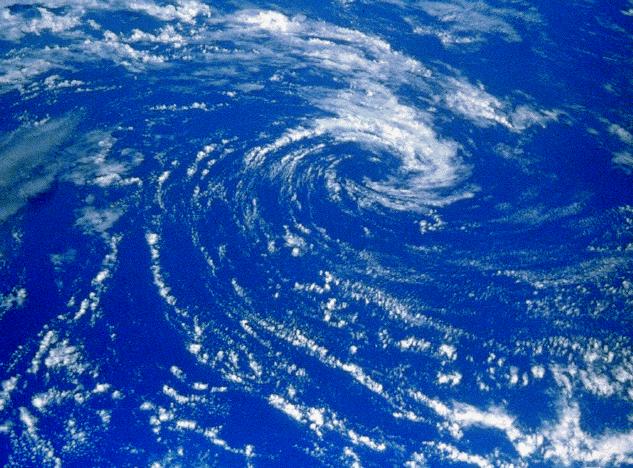
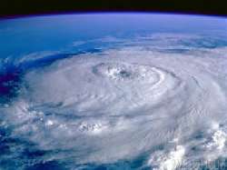
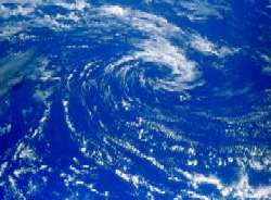
1. Eye of the Storm, Hurricane Elena
© Dreamtime, NASA's Multimedia Partner
|
|
 |
|
|
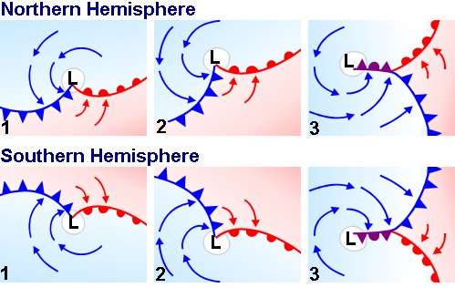
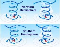
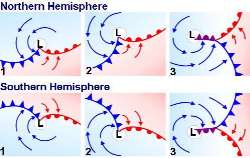
2. In cyclones, the winds move anti-clockwise around a low pressure centre in the northern hemisphere. In the southern hemisphere the wind direction is reversed. Figure: volvooceanadventure ©
|
|
|
Low pressure systems Cyclones
Regions of rising air are called lows, low pressure systems, depressions or cyclones. These are systems of closed isobars (lines of constant pressure) surrounding a region of relatively low pressure. Cloudy conditions, windy weather, rain and snow and unsettled changable weather often occur in these regions.
A low pressure system develops when relatively warm and moist air rises from the surface of the Earth. Air near the centre of a low pressure system is unstable. As the warm humid air spirals upwards, it cools and clouds form. These may be thick enough to give rain or snow.
In these low pressure systems the air spirals inwards at the Earths surface. If the pressure is very low, these spiralling winds may reach storm or hurricane force. This is why the term cyclone is often loosely applied to storms generated by low pressure systems.
|
|
Tropical and midlatitude cyclones
There are two types of cyclones, they develop in different ways and have different structures.
Tropical cyclones
|
 |
|
|
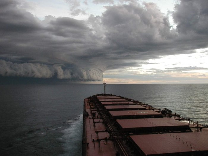
Tropical cyclones develop over the ocean in warm and moist tropical air masses at latitudes between 20o and 25o north or south of the equator. They are characterised by very low air pressure at their centre and are small in size, just 100 to 1500 km in diameter. This means that there is a very strong pressure gradient across the cyclone and this can lead to very strong hurricane strength winds.
Wind speeds in hurricanes are over 33 m s-1 (120 km h-1), with a record of 104 m s-1 during hurricane Allen in 1980, that's a wind speed of 375 km h-1!
Tropical cyclones gain their energy from the latent heat of evaporation of water from the ocean. They therefore gradually dissipate when they move across land and lose their energy source.
|
|
|
 |
|
|
3. left: Tropical cyclone Graham in the Pacific Ocean. Source: www.gowilmington.com
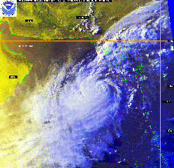
4. right: NOAA satellite imagery showing strong Tropical Cyclone 03A moving northeast across the Arabian Sea toward landfall in northwest India. source: weather.ou.edu
Click for larger images! left: 62 kB, right: 275 kB.
|
|
|
Please read also about tropical cyclones, hurricanes and expectations for the future in the ACCENT school magazine: special edition on hurricanes
Midlatitude cyclones
|
 |
|
|
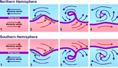
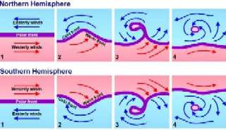
5. left: The way weather fronts develop around a low pressure system.
6. right: The development of midlatitude cyclones north of the Equator (top) and south of the Equator (bottom).
Source: volvooceanadventure ©
Please click on the pictures to enlarge them!
|
|
|
 |
|
|
Midlatitude cyclones are powered by large temperature differences in the atmosphere. They develop when air masses of different temperatures meet. The air masses do not mix together, rather the warmer air is forced up over the colder air. This causes a front to form (see also chapter 3).
Midlatitude cyclones are much larger than tropical cyclones. They have diameters of between 1000 and 4000 km and they also have lower wind speeds.
The maximum wind speed in a midlatitude cyclone is around 30 m s-1 (110 km h-1).
|
|
High pressure systems - anticyclones
Regions of sinking air are called highs, high pressure regions or anticyclones. They are usually accompanied by constant, good or fair weather. High pressure systems tend to cover a greater area than lows, they move more slowly and have a longer atmospheric lifetime.
Anticyclones are produced by a large mass of descending air. As the air sinks, it warms up, the atmospheric pressure increases and the relative humidity decreases. This causes water droplets in the air to evaporate and leads to dry weather.
|
|
 |
|
|
7. In anticyclones the winds move clockwise around a high pressure centre in the northern hemisphere. In the southern hemisphere the wind direction is reversed (see Figure 2). Source: www.geologia.com
Please click on the picture to enlarge!
|
|
The warm, sinking air makes the atmosphere stable, so warm air at the surface of the Earth cannot rise far before it stops. This prevents tall clouds from forming. For this reason anticyclones usually lead to warm, dry weather and cloudless skies in the summer and cold, dry weather in the winter. These conditions usually lasts for several days or even weeks.
Anticyclones are much larger than cyclones and may block the path of depressions. This slows down the arrival of bad weather or forces it to travel elsewhere. An anticyclone that persists for a long period is known as a 'blocking high' and these lead to long hot spells and even droughts during the summer and extremely cold winters.
|
|
 |
|
|
8. Anticyclone conditions over France and much of western Europe. The skies are cloudless and the weather is fair. Source: Passion Meteo, photograph taken from space by a NOAA satellite.
|
|
About this page:
author: Vera Schlanger - Hungarian Meteorological Service
scientific reviewing: Dr. Ildikó Dobi Wantuch / Dr. Elena Kalmár - Hungarian Meteorological Service, Budapest
last updated: 2004-02-23 |
Further reading:
www.bom.gov.au
www.scalloway.org.uk
www.geocities.com
www.wxresearch.org
www.volvooceanadventure.org
www.ace.mmu.ac.uk
www.docm.mmu.ac.uk
www.ecn.ac.uk |