 > ENC Master > Climate Encyclopaedia > Clouds & Particles > more > 1. What happens in clouds? > - Cloud particularities
 |
|
|
|
Clouds & ParticlesMore |

Cloud particularitiesIn the "Basics" section, the different genera of clouds were explained. Clouds are classified in 4 groups depending on the height of the cloud's base and its thickness. We'll have a look here at a smaller scale inside the different clouds and focus on their particularities.
|
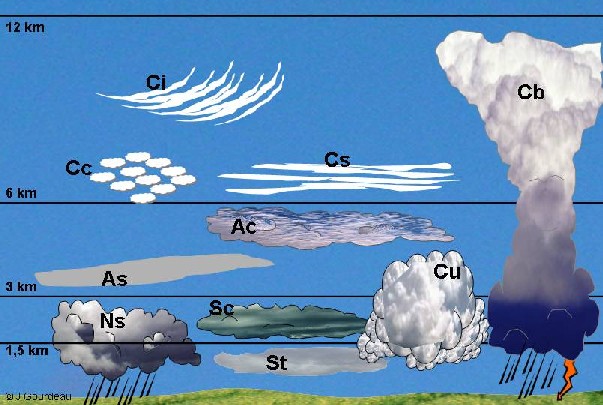
The different types of clouds and their precipitations: an overviewTroposphere (the lower part of the atmosphere, where life is possible) can be virtually divided in three levels: the low level, the mid-level and the high level. These levels are roughly defined and depend on the latitude considered. In Europe, it is found that low clouds occur at altitudes of up to 2 km whereas medium level clouds extend to about 6 km. The highest clouds are found at altitudes up to 12 km.
|
 |
|
1. The different clouds in the troposphere. St: stratus, Sc: stratocumulus, Nb: nimbostratus; Ac: altocumulus, As: altostratus; Ci: cirrus, Cs: cirrostratus, Cc: cirrocumulus; Cu: cumulus, Cb: cumulonimbus.
|
|
Some clouds precipitate, others don't. Only Stratus clouds are able to drizzle, whereas hail is originated from Cumulonimbus only. High-level clouds and Altocumulus hardly never rain.
|
|
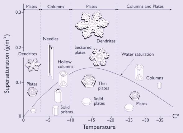
High level clouds: the ice crystalsThe highest clouds, like cirrus, are made of tiny ice crystals rather than liquid cloud droplets. A typical small snow crystal might contain between 1016 and 1018 water molecules. Although not two snow crystals are exactly alike, there are several basic types of crystals. The crystal shape depends mainly on temperature, as shown in the diagram 2.
|
|
|
Snowflakes are simply aggregates of ice crystals. As long as the snowflakes do not pass through a layer of air warm enough to cause them to melt, they remain intact and reach the ground as snow.Although they are only composed of ice crystals, high level clouds never produce snow because their crystals are too small to precipitate. |
|
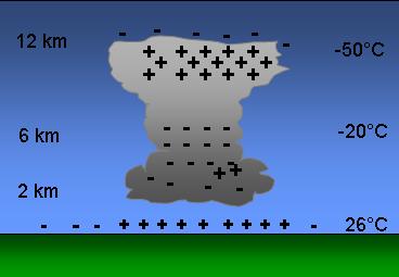
Cumulonimbus and thunderstormsIn summer, through the atmospheric processes of strong diurnal heating, the lower atmosphere becomes warm and moist, whereas the upper atmosphere is colder. Atmosphere is unstable. Convection forces the air at the ground level to rise, and it condenses into water droplets. With the release of latent energy caused by water condensation, convection is further accelerated and a towering cumulonimbus cloud is forming (that can reach 15 km height in 30 minutes, while millions tons of water are lifted). |
Mechanism of lightning is still not well known. Water droplets, ice crystals, hailstones inside the cumulonimbus collide because of the strong air currents. friction then creates static electricity. Positive charges build up at the top of a cloud and negative ones build up at the bottom. The ground underneath is positively charged. The difference between charges gets bigger until lightning sparks across the gap. The amount of energy stored by a cumulonimbus cloud is so huge that is it of the same scale as a small atomic bomb. |
|
|
Lightning, that travel until 40 000 km per second, can generate 100 millions volts of electricity and air in the lightning path is heated to around 30 000°C. This temperature is so hot that air expands violently, like popcorn, and creates sound waves called thunder. |

|
About this page.... |