|
|
 |
|
|
|
|
| |
|
|
|
Clouds & Particles
More |
Characteristics of the different cloud types
In the 'basics' section we looked at the different types of clouds and showed that clouds are classified into four groups depending on the height of the cloud base and the cloud thickness. In this 'read more' section we will look at the different cloud types in more detail.
|
|
|
|
|
|
The different types of clouds: an overview
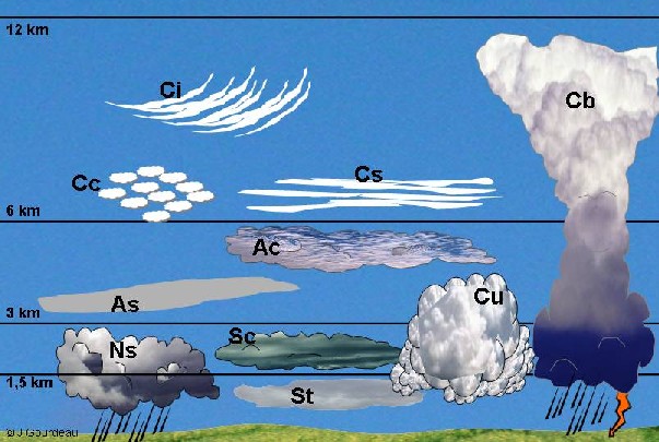
The lower layer of the atmosphere, the troposphere, can be divided into three layers: the lower level, the mid level and the upper level. These levels don't have firm definitions and their height depends on the latitude considered. In Europe, low level clouds occur at altitudes of up to 2 km whereas medium level clouds extend to about 6 km. The highest clouds are seen at altitudes of up to 12 km.
|
 |
|
|
1. The different types of cloud in the troposphere. St: stratus, Sc: stratocumulus, Nb: nimbostratus; Ac: altocumulus, As: altostratus; Ci: cirrus, Cs: cirrostratus, Cc: cirrocumulus; Cu: cumulus, Cb: cumulonimbus. Author: J. Gourdeau. Click to enlarge (75 K).
|
|
Some clouds generate rain, others don't. You can only get drizzle from stratus clouds and can only get hail from cumulonimbus clouds. High level clouds and altocumulus clouds hardly ever rain. The table on the right shows what type of precipitation you can get from each cloud type.
|
|
|
|
As |
Ns |
Sc |
St |
Cu |
Cb |
|
Rain |
a |
a |
a |
|
a |
a |
|
Drizzle |
|
|
|
a |
|
|
|
Snow |
a |
a |
a |
|
|
a |
|
Hail |
|
|
|
|
|
a |
|
High level clouds: Ice crystals
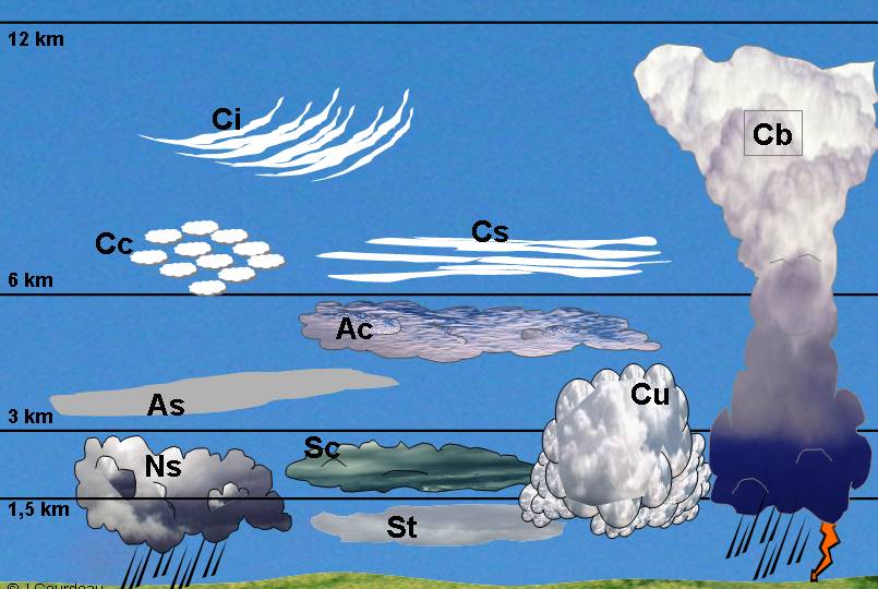
The highest level clouds, like cirrus, are made of tiny ice crystals rather than liquid water droplets. A typical small ice crystal contains between 1016 and 1018 water molecules. Although no two ice crystals are exactly alike, there are several basic types of crystals. The crystal shape depends mainly on temperature and this is shown in figure 2.
Snowflakes are simply aggregates of ice crystals. As long as the snowflakes do not pass through a layer of air warm enough to make them melt, the snow flakes remain intact and reach the ground. Although they are only made up of ice crystals, high level clouds never produce snow because their crystals are too small, and therefore not heavy enough to fall.
|
|
 |
|
|
2. The different shapes of ice crystals according to the air temperature and degree of supersaturation. Source: www.snowcrystals.com. Click to enlarge! (58K).
|
|
 |
|
|
3. A dog in the snow! Source, M. Ruinhart.
|
|
|
The record for the most snow falling in a single day is held by Silver Lake, Colorado in the United States of America. On the 15th April 2001, 192 cm of snow fell!
|
Low level clouds: stratus, stratocumulus and nimbostratus and fog
Clouds at low levels form as a result of condensation of water vapour into liquid cloud droplets. Stratus clouds form a layer near the ground that is typically only a few hundred meters thick. Only stratus clouds produce drizzle, which we define simply as water droplets less than 0.5 mm in diameter. They fall so slowly that they seem to remain suspended in the air.
|
Cumulonimbus clouds and thunderstorms
In summer, strong daytime heating warms the lower atmosphere making it warm and moist. This warm air rises by convection and, since the air above is colder, this makes the atmosphere unstable. Water vapour in the rising air condenses into water droplets as the warm air cools. This condensation process releases more heat into the atmosphere and convection is further accelerated. A towering cumulonimbus cloud forms in just 30 minutes which can reach upto 15 km in height and millions tonnes of water are lifted from the ground into the sky.
|
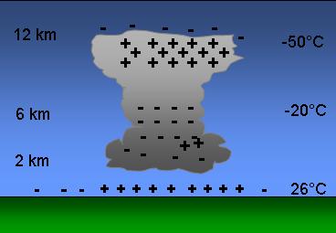
We still don't know the exact way lightning forms. Water droplets, ice crystals and hailstones inside the cumulonimbus cloud collide because of the strong air currents which exist in the cloud. Friction then creates static electricity. Positive charges build up at the top of the cloud and negative ones build up at the bottom. The ground underneath is positively charged. The difference between charges gets bigger and bigger until lightning sparks cross the gap. The amount of energy stored by a cumulonimbus cloud is huge, about the same amount as a small atomic bomb!
|
|
 |
|
|
4. Illustration of the electrical structure of a thundercloud. Author: J. Gourdeau.
|
|
 |
|
|
5. Lightning strikes seen during a night-time thunderstorm. Source: NOAA.
|
|
|
Lightning travels at upto 40,000 km per second and can generate 100 millions volts of electricity. This heats the air in the path of the lightning flash to around 30,000°C! This temperature is so hot that the air expands violently, like popcorn, and creates sound waves which we hear as thunder.
|
About this page
author: Dr. Justine Gourdeau - LaMP, Clermont-Ferrand, France
scientific reviewer: Prof. Jean-Francois Gayet - LaMP, Clermont-Ferrand, France
last published: 2004-04-22
|
|
|
|