espere Environmental Science Published for Everyobody Round the Earth
Printer friendly version of this page
Home    Contact    Encyclopaedia    Mobility    International    PDF    magazine    - ? -   
Weather
basics
1. Weather & Fronts
- Weather and climate
- Pressure systems
- Fronts
* Worksheet 1
* Worksheet 2
* Worksheet 3
* Worksheet 4
* Worksheet 5
2. Circulation Systems
3. Folklore Weather Forecasting
Links
PDF
more


Download

 
weather

Weather

Basics


1. Weather and fronts

Worksheet 2:
Satellite view of a cold front

.


basicsmore
basicsmore
basicsmore
basicsmore
basicsmore
basicsmore
basicsmore
basicsmore
 

Excercise:

This satellite image shows a cold front above Central Europe.
Download the worksheet and print it out.

Mark the words shown in bold in the text on the picture and draw in the position of the Alps, the Po delta and the border of the extreme weather.


satellite view of strong cyclone

1. Low (Baltic Sea); 9th of Sept. 2001, 9:16 - 14:44 UTC, NOAA VIS
author: Bernhard Muehr, Institute for Meteorology and climate science Berlin, University of Karlsruhe
Source: http://www-imk.physik.uni-karlsruhe.de/~muehr/Sat/satsp141.htm
Please click to enlarge!


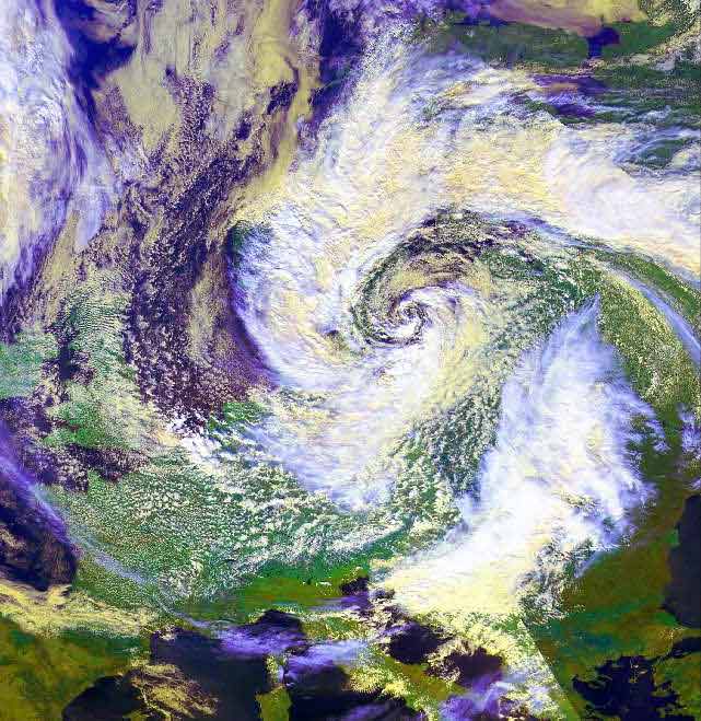
This satellite image shows the impressive swirl-structure of a strong cyclone with its centre above the East European Sea.

The cold air moves along a broad bow above Northwest, Middle and East Europe into the centre of the cyclone.

The plain of the Po delta, on the leeward-side of the Alps, is almost free of clouds.

Further east a broad, bright band of clouds marks the border with continental warm air above southeast Europe.  At this border extreme weather events are normal.


About this page:
author: Dr. Yvonne Schleicher - University of Nürnberg, Germany
educational reviewing: Prof. Dr. Helmut Schrettenbrunner and Julia Heres - University of Nürnberg, Germany
last update: 2003-08-09


 top

ESPERE / ACCENT

last updated 02.03.2006 18:53:29 | © ESPERE-ENC 2003 - 2013