|
|
 |
|
|
|
|
| |
|
|
|
Clouds & Particles
More |
Formation of droplets
A cloud forms when humid air is cooled enough so that the water vapour it holds becomes liquid. In this section we look at the relationship between temperature and the amount of water vapour the air can hold and what affects the size of water droplets in a cloud.
|
|
|
|
|
|
Saturation of air
The quantity of water vapour that air can hold depends on its temperature. For a given temperature, the relationship between the amount of water a given mass of air actually holds and the total amount it can hold is known as the relative humidity.
Air is said to be saturated when it holds as much water vapour as it can. Saturated air, therefore, has a relative humidity of 100%. Supersaturated air has a relative humidity of more than 100%.
The table below shows the maximum amount of water vapour the air can hold at different temperatures, before condensation begins.
|
|
T°C |
-20 |
-10 |
0 |
+10 |
+20 |
+30 |
|
Amount of water vapour
(g water per m3 of air) |
1.1 |
2.3 |
4.8 |
9.4 |
17.3 |
30,5 | |
|
For example, imagine an air parcel at 20°C that contains 9.4 g m-3 of water vapour. The relative humidity of the air is therefore (9.4/17.3) x 100 = 54.3%. Now assume the air parcel cools down to 10oC (for example by rising in the atmosphere), at this point the air is now saturated and the relative humidity is 100%.
Now imagine that the air rises further and the temperature falls to 0°C. At 0oC, air can only hold 4.8 g m-3 of water vapour and the air parcel is now supersaturated by (9.4 - 4.8) = 4.6 g of water. This extra water condenses on available aerosol particles forming cloud droplets and the relative humidity of the air parcel returns to 100%.
|
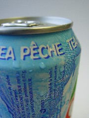
The warmer the air, the more water it can hold. This is why warm air is used to dry objects, it absorbs moisture. On the other hand, if saturated air is cooled down, the water vapour in the air is forced to condense into water droplets. This is why water droplets are seen on the outside of a cold soft drinks can . The cold can cools the air around it causing the water vapour in the air to condense.
|
|
 |
|
|
1. A cold drink can 'sweating'.
Source: C. Gourbeyre.
|
|
Water droplets inside clouds
Cloud droplet diameters vary from a few micrometers to more than 100 µm (0.1 mm), with the average droplet size being around 10 µm in diameter.
- Continental clouds are generally made up of many small droplets.
- Marine clouds are made up of fewer droplets but the droplets are large.
- There are usually between 25 000 and 1 million water droplets per litre of air.
- The distance between 2 droplets is around 1.4 mm, a distance about 70 times the diameter of each droplet (it's perhaps easier to visualise this as a football on the ground every 20 or 30 meters).
- In order to fall as rain, droplets need to grow until they reach a diameter of around 1 mm, that's about one hundred times bigger than the droplet was originally!
|
 |
|
|
2. Author: J. Gourdeau.
|
|
|
For "warm clouds" (those which don't contain ice crystals), droplets grow to rain drop size by sticking to each others. As times passes, the droplets become larger and larger until they are too heavy to remain suspended in the air by the up-drafts that counterbalance the droplets falling.
In cumulonimbus clouds, for example, the up-drafts are very strong. This means that droplets can grow to very large sizes before they become too large to remain suspended in the air. This is why the raindrops are so big during thunderstorms.
|
|
Colder clouds are made up of ice crystals, liquid water and water vapor. Water vapour condenses onto the ice crystals and liquid droplets freeze when they come into contact with the ice crystals. As the ice crystals become bigger and bigger, they start to fall as snow, or rain if they melt before reaching the ground.
|
 |
|
3. Source: freefoto.com |
|
|
 |
|
4. Source: fond-ecran-image.com |
|
About this page
author: Dr. Justine Gourdeau - LAMP, Clermont-Ferrand, France
scientific reviewer: Prof. Jean-Francois Gayet - LaMP, Clermont-Ferrand, France
last published: 2004-04-22
|
|
|
|


