|
|
 |
|
|
|
|
| |
|
|
|
Weather
Basics |
El Niño, La Niña, global impacts
El Niño
El Niño is a large-scale ocean-atmosphere climate phenomenon in the tropical Pacific. It represents the warm phase of the periodic warming of the sea-surface. It typically appears around Christmas time (and this is why it is called El Niño, as this is Spanish for the 'Christ Child'). It can last for up to a year.
|
|
|
|
|
|
El Niño affecting the world ...
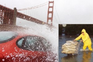
1. Flood in San Francisco. During the winter of 1997/98, wind-driven waves and abnormally high sea levels significantly contributed to hundreds of millions of dollars in flood and storm damage in the San Francisco Bay region. Recent analyses by U.S. Geological Survey (USGS) scientists of nearly 100 years of sea-level records collected near the Golden Gate Bridge found that these abnormally high sea levels were the direct result of that years El Niño atmospheric phenomenon.
from: USGS Fact Sheet
|
|
|
 |
|
|
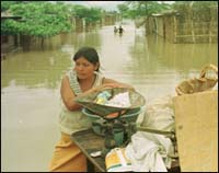
2. Flood in Lima. © Reuters
|
|
|
2. More than 35,000 people have been evacuated and nearly 7,000 people remain isolated by the flooding of the Paraguay river. Abnormally heavy rains associated with the El Nio phenomenon have caused flooding affecting 60,000 people in Paraguay's capital , Asuncion, and the provinces of Concepcion, Alberdi, San Pedro, Presidente Hayes and Alto Paraguay.
from: UNDP Desaster Protection, 1998 Jan, 8th
LIMA, 2002 May 9 (AlertNet) - In April, the normally calm Piura River turned overnight into a raging torrent. More than 3,500 families in northern Peru escaped but lost their homes and livelihoods. Scientists disagreed over whether the dramatic weather was connected to the climate phenomenon El Niño, due to make a reappearance this year.
from: Reuters alert net
|
The warm ocean current which flows during El Niño influences the weather around the globe. El Niño events cause increased rainfall, flooding and storms, but also drought and sometimes devastating fires.
What drives El Niño?
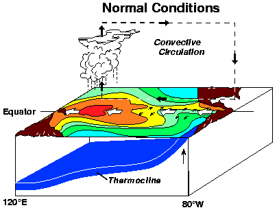
During non-El Niño conditions, the sea surface temperature (SST) in the tropical Pacific is between 6 and 8 oC higher in the west than in the east. This temperature difference is caused mainly by the easterly trade winds. These blow warm surface water across the tropical Pacific from east to west. The surface water gets progressively warmer as it moves west because it is exposed to longer solar heating.
|
|
 |
|
|
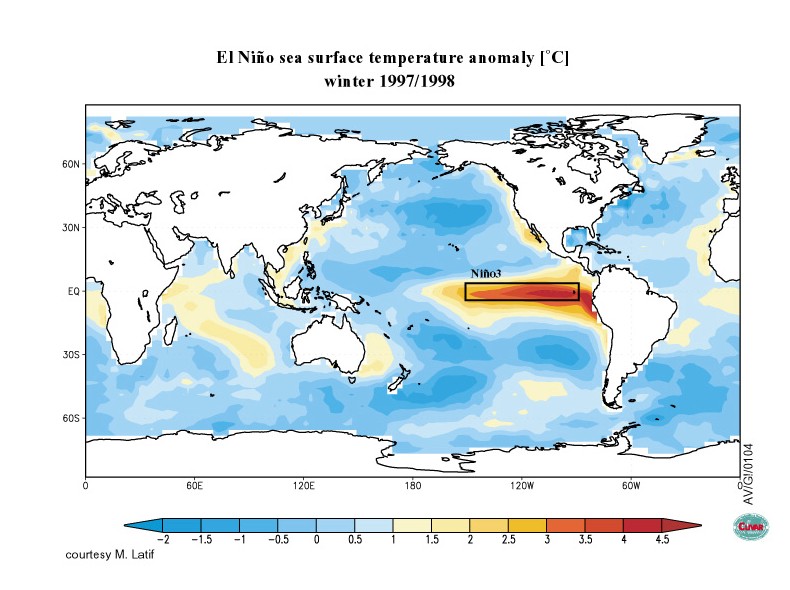
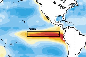
3. Sea surface temperature anomaly. Please click on the picture to see a larger view of the sea surface temperature anomaly during an El Niño event. The picture does not show the ocean temperature but rather shows how much warmer (in red) or how much cooler (in blue) the sea is during El Niño compared to its normal state. West of South America in front of the Peruvian coast, the water is a lot warmer than normal. © clivar.org / Mojib Latif, MPI Hamburg
|
|
 |
|
|
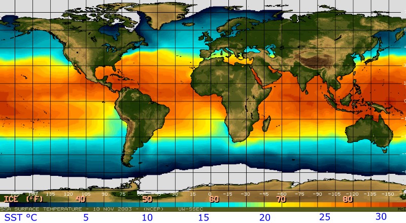
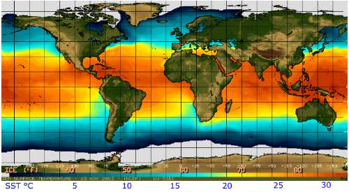
4. Sea surface temperatures in absolute values, °Celsius and °Fahrenheit, in November 2003. This image shows normal conditions with cool water from the Humboldt Stream along the South American west coast. Source: SSEC University of Madison, Wisconsin, USA. Click on the figure for a higher resolution picture (130 K).
|
The wind blows the seawater west and, as a result, the sea surface is about half a metre higher at Indonesia than at Ecuador. Because of this difference in seasurface height, water is upwelled from deeper in the ocean in the east to reduce the disparity in height (Figure 4a.). This cool, nutrient-rich sea water is very important in terms of fishing.
|
|
 |
|
|
5 a) 3-D model of the Pacific Ocean with the South American continent on the right and Australia on the left. This shows the normal conditions in the Pacific.
Please click to enlarge!
|
|
During El Niño years, weakened winds reduce the flow of water from the east to the west and less nutrient rich cold deep water is upwelled to the surface along the South American coast. So surface waters are warmer than normal but also contain less nutrients. As a result, a dramatic reduction in marine fish and plant life is seen during El Niño events. Most importantly, the warmer than normal water makes the atmosphere unstable and this causes changes in rainfall and weather around the globe.
El Niño episodes occur every 2-7 years.
|
|
|
|
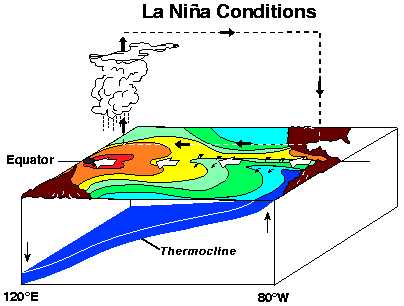
La Niña
Compared to El Niño, La Niña (the female child) events are characterised by cooler than normal sea-surface temperatures in the central and eastern tropical Pacific Ocean.
|
During La Niña, the easterly trade winds strengthen and upwelling of cold deep water along the equator and the west coast of South America intensifies. Sea-surface temperatures drop as much as 4 oC below normal. The event also called anti-El Niño, or simply "a cold event" or "a cold episode". La Niña conditions make the atmosphere very stable and tend to cause opposite climatic effects to El Niño.
La Niña events occur about half as often as El Niño events do.
|
|
|
|
Between 1950 and 1997, El Niño events occurred 31% of the time, La Niña events occurred 23% of the time and normal conditions were seen around 46% of the period. El Niño and La Niña events occur, on average, every 3 to 5 years. Based on the historical record, the interval between events has varied from 2 to 7 years. Since 1975, La Niña events have been only half as frequent as El Niño events. A La Niña episode may, but does not always, follow an El Niño. La Niña conditions typically last for 9-12 months, but some episodes may persist for as long as two years.
La Niña events do not negatively affect fisheries in the same way as El Niño events and so are less well known. However, both affect global climate.
|
The global impacts of El Niño and La Niña
The impacts of El Niño and La Niña are seen mostly in the Pacific Ocean and along the Equator. Their effects on temperature and rainfall are roughly opposite and are shown in the figures below.
|
 |
|
|
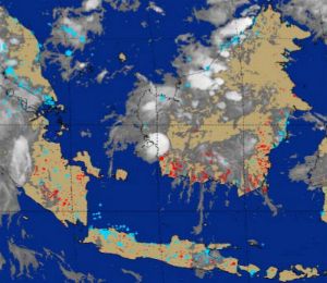
7. Fires in Indonesia - Sept. 30th, 1997. The strong El Niño event from mid 1997 to mid 1998 increased the incidence of dangerous fires in Indonesia in this year. © NOAA / significant event imagary.
Please click to enlarge!
|
|
|
In the tropics, the eastward shift of thunderstorm activity from Indonesia into the central Pacific during warm episodes results in abnormally dry conditions over northern Australia, Indonesia and the Philippines in both seasons. Drier than normal conditions are also observed over southeastern Africa and northern Brazil during the northern winter season. During the northern summer season, Indian monsoon rainfall tends to be less than normal, especially in northwest India where crops are adversely affected. Wetter than normal conditions during warm episodes are observed along the west coast of tropical South America and at subtropical latitudes of North America and South America.
|
|
During a warm episode winter, mid-latitude low pressure systems tend to be more vigorous than normal in the eastern North Pacific. These systems pump abnormally warm air into western Canada, Alaska and the extreme north of the United States. Storms also tend to be more vigorous in the Gulf of Mexico and along the southeast coast of the United States resulting in wetter than normal conditions in that region.
No one clear impact has been detected in Europe yet. This does not mean that El Niño and La Niña do not influence the weather in Europe, but that the connection between these processes is not very strong.
|
About this page:
author: Vera Schlanger - Hungarian Meteorological Service
scientific reviewing: Dr. Ildikó Dobi Wantuch / Dr. Elena Kalmár - Hungarian Meteorological Service, Budapest
last updated: 2003-10-28 |
|
Further reading:
http://geology.wr.usgs.gov
http://www.cpc.ncep.noaa.gov
http://www.pmel.noaa.gov
http://www.ogp.noaa.gov
http://ww2010.atmos.uiuc.edu
http://www.jpl.nasa.gov
http://www.al.noaa.gov
http://ess.geology.ufl.edu
http://www.elnino.noaa.gov
|
|
|
|