|
|
 |
|
|
|
|
| |
|
|
|
Weather
More |
NAO
North Atlantic Oscillation (NAO)
Climate variability comprises three primary, but interrelated phenomena in the North Atlantic region:
- the Tropical Atlantic Variability
- the North Atlantic Oscillation
- the Atlantic Meridional Overturning Circulation.
The NAO is a fluctuation in a sea level pressure difference between Iceland and the Azores. The name was first cited by Gilbert Walker in 1924.
|
|
|
|
|
|
The history of the NAO
The NAO has a long history. The missionary Hans Egede Saabye made observations in his diary as far back as 1770 to 1778: "When the winter in Denmark was severe, as we perceive it, the winter in Greenland in its manner was mild, and conversely". Simultaneously, coherent fluctuations in temperatures, rainfall and sea level pressure were documented, reaching eastwards to central Europe, southwards to subtropical West Africa and westward to North America.
The fluctuations of NAO influence climate from North America to Siberia and from the Arctic Ocean to the equator.
NAO index
The strength of the NAO is described by the NAO index. The NAO index is the difference of sea-level pressure between two stations situated close to the centres of the Icelandic Low and the Azores High. Stykkisholmur (Iceland) is used as the northern station, and either Ponta Delgada (Azores), Lisbon (Portugal) or Gibraltar are used as the southern station.
This simple index clearly does not take into account the possibility that the centres of the actual pattern may not overlap with these locations, nor can it accurately capture the seasonal variations in the NAO. However, there is a key advantage to the use of such an index, existing weather records allow it to be extended back in time to at least 1864. When the index is correlated or regressed with gridded surface pressure data, the resulting north-south dipole pattern defines the spatial pattern of the NAO.
|
 |
|
|
1. source: http://www.ldeo.columbia.edu/
res/pi/NAO/
Please click to enlarge!
|
|
|
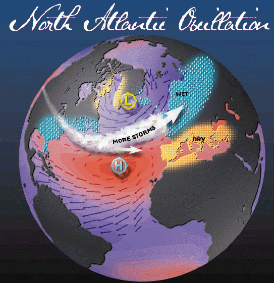
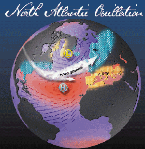
The positive NAO index phase shows a stronger than usual subtropical high pressure center and a deeper than normal Icelandic low. The increased pressure difference results in more and stronger winter storms crossing the Atlantic Ocean on a more northerly track. This results in a warm and wet winters in Europe and in cold and dry winters in northern Canada and Greenland. In this case, the eastern US experiences mild and wet winter conditions. For example, the high index winter/springs of 1989, 1990, and 1995, were caused by a net displacement of air from over the Artic and Icelandic regions towards the subtropic belt near the Azores and the Iberian peninsula, and had strengthened westerlies over the North Atlantic Ocean. Stronger westerlies bring more warm moist air over the European continent and gives rise to milder maritime winters. |
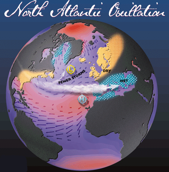
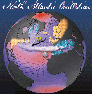
The negative NAO index phase shows a weak subtropical high and a weak Icelandic low. The reduced pressure gradient results in fewer and weaker storms crossing on a more west-east pathway. They bring moist air into the Mediterranean and cold air outbreaks and hence snowy weather conditions. Greenland, however, has milder winter temperatures. The low index winter/springs of 1917, 1936, 1963, and 1969 had weaker mean westerlies over the North Atlantic Ocean with corresponding colder than normal European winters.
|
|
 |
|
|
2. source: http://www.ldeo.columbia.edu/
res/pi/NAO/
Please click to enlarge!
|
|
|
Strengthened or weakened westerlies over the North Atlantic both have major impacts on oceanic and some continental ecosystems. They have a large impact on North Atlantic fish stocks.
|
 |
|
|
3. source: http://www.ldeo.columbia.edu/res/pi/NAO/
|
|
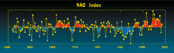
The winter NAO index is defined as the anomalous difference between the polar low and the subtropical high during the winter season (December through March).
NAO index has exhibited considerable variability over the past 100 years. From the turn of the century until about 1930 (with exception of the 1916-1919 winters), the NAO was high and so stronger-than-usual winds carried the moderating influence of the ocean over Europe contributing to the higher-than-normal European temperatures during this period. From early 1940's until the early 1970's, the NAO index exhibited a downward trend corresponding to a period when European wintertime temperatures were frequently lower than normal. A sharp increase in the NAO has occurred over the past 25 years. Since 1980, the NAO has remained in a strongly positive phase and displayed an upward trend. Since the turn of the 20th century, winters have exhibited the most pronounced positive indices ever recorded (except 1996). This situation has contributed much to the observed warming seen in northern hemisphere surface temperatures over the past two decades.
|
About this page:
author: Sándor Szalai - Hungarian Meteorological Service
scientific reviewing: Dr. Ildikó Dobi Wantuch / Dr. Elena Kalmár - Hungarian Meteorological Service, Budapest
last updated: 2003-10-28
|
|
References:
Marshall, J. et al., 2001: Nort Atlantic climate variability: phenomena, impacts and mechanisms. Intl Journal of Climatology, 1863-1898 pp.
|
|
|
|