|
|
 |
|
|
|
|
| |
|
|
|
Weather
More |
Major wind systems, the trade winds, monsoons
Major wind systems
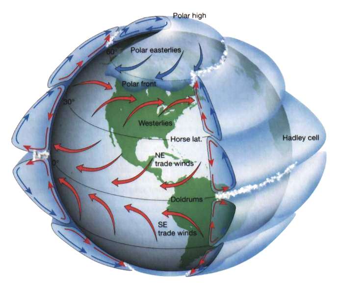
The major effecting components of the climate system are the incident solar radiation, the distribution of the continents and oceans, the rotation of the Earth and the orography. The most of the solar energy is coming into the equatorial belt. Here, the equatorial belt of calms or the doldrums lies around the equator centered slightly north of the equator between the two belts of trade winds (see later).
|
|
|
|
|
|
 |
|
|
1. Rotating Earth - Global Circulation
Source: website of University of Michigan-Ann Arbor, Department of Geological Sciences
Please click on the picture for better resolution! (38K)
|
|
|
The large amount of solar radiation that arrives at the earth in this area causes intense heating of the land and ocean. This heating results in the rising of warm moist air, low air pressure, cloudiness, high humidity, light, variable winds, and various forms of severe weather, such as thunderstorms and squalls. Hurricanes originate in this region. The doldrums are noted for calms, periods when the winds disappear, trapping sailing vessels for days or weeks.
This rising air descends at the so called horse latitudes. These are two belts of latitude where winds are light and the weather is hot and dry. They are located mostly over the oceans, at about 30° latitude in each hemisphere, and have a north-south range of about 5° as they follow the seasonal migration of the sun.
|
|
The descending air after reaching the earths surface, spreads toward the equator as part of the prevailing trade winds or toward the poles as part of the westerlies. The belt in the Northern Hemisphere is sometimes called the calms of Cancer and that in the Southern Hemisphere the calms of Capricorn. The term horse latitudes supposedly originates from the days when Spanish sailing vessels transported horses to the West Indies. Ships would often become becalmed in mid-ocean in this latitude, thus severely prolonging the voyage, the resulting water shortages would make it necessary for crews to throw their horses overboard.
|
Trade winds
The air at doldrums rises high over earth, recirculates poleward, and sinks back toward the earths surface in the region of horse latitudes, and converge near surface to the doldrums. Surface air from the horse latitudes that moves back toward the equator and is deflected by the Coriolis Force, causing the winds to blow from the NE in the Northern Hemisphere and from SE in the Southern Hemisphere is called trade winds. It means that in both hemispheres, they tend to blow from the east to the west and towards the equator. Sometimes the trade winds will just be called "easterly" to avoid having to specify the hemisphere. These steady winds are called trade winds because they provided trade ships with an ocean route to the New World.
|
|
 |
|
|
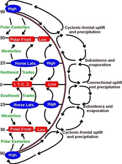
2. Global Circulation
source: San Francisco State University (SFSU) website
Please click on the graphics for higher resolution (51K)
|
|
 |
|
|
3. Effect in the Indian sub-continent - Monsoon
© 1996 EarthBase/Liaison Agency. All rights reserved.
Photo by Chip Hires
|
|
|
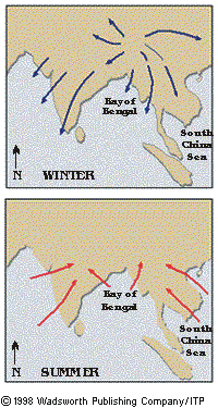
Monsoons
A monsoon circulation is determined by the different heat capacity characteristics of continents and oceans, e.g. similar to a sea/land breeze, except that is occurs over a much larger area. In summer, the winds usually flow from the water to the land, causing heavy rains inland. In winter, the winds usually reverse, and the flow from the land to the sea results in dry conditions.
The word "monsoon" is derived from the Arabic word "mausim" which means season. Ancient traders sailing in the Indian Ocean and adjoining Arabian Sea used it to describe a system of alternating winds which blow persistently from the northeast during the northern winter and from the opposite direction, the southwest, during the northern summer. Thus, the term monsoon actually refers solely to a seasonal wind shift, and not to precipitation.
|
Even though the term monsoon was originally defined for the Indian subcontinent, monsoon circulations exist in other locations of the world as well, such as in Europe, Africa, Australia, and the west coasts of Chile and the United States. Approximately 65 % of the worlds population lives within monsoon regions. The most famous monsoon circulation occurs over India and southeast Asia. During the summer, the air over the continent becomes much warmer than the water surface, so the surface air moves from the water to the land. The humid air from the water converges with dry air from over the continent and produces precipitation over the region. Additional lifting from hills and mountains causes copious amounts of precipitation to occur, over 400 inches at some locations! During the winter the flow reverses and the dominant surface flow moves from the land to the water.
The Indian summer monsoon typically lasts from June through September. During this period large areas of western and central India receive more than 90% of their total annual rainfall, while southern and northwestern India receive 50%-75% of their total annual rainfall. Overall, monthly rainfall totals average 200-300 mm, with the largest values observed during the heart of the monsoon season in July and August.
|
|
 |
|
|
4. Monsoon Circulation
source: Homepage of the Cooperative Institute for Mesoscale Meteorological Studies
Please click on the figure to enlarge it! (57K)
|
|
|
Rainfall across southeastern Asia is also monsoonal in nature, with the largest totals typically observed during May-September. Area-average totals normally reach 200 mm in each of these months, with seasonal totals of 1000 mm commonly observed.
|
About this page:
Author: Sándor Szalai - Hungarian Meteorological Service
Scientific reviewing: Dr. Ildikó Dobi Wantuch / Dr. Elena Kalmár - Hungarian Meteorological Service, Budapest
Last updated: 2003-11-13
|
Further reading:
www.infoplease.com/ce6/weather
|
|
|
|