|
|
 |
|
|
|
|
|
Weather
Weather is defined as the short term, local state of the atmosphere and shouldn't be confused with climate. Meteorologists define climate as the long term pattern of weather conditions. To determine the climate of a particular region, we collect information on the weather over a specific time interval, usually several decades. So how do we go about determining our weather?
|
|
 |
|
|
Encyclopaedia
Link to topic
Weather
|
|
Local observation
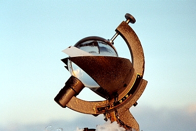
Observing our weather involves taking measurements of different parameters:
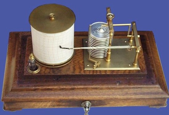
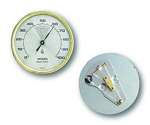
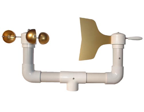
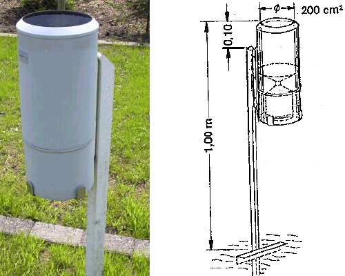
- air pressure with a barometer
- temperature with a thermometer
- humidity with a hydrograph or psychrometer
- wind direction and wind speed with an anemometer
- precipitation (rain, snow) with a rain gauge
- radiation e.g. with a sunshine autograph or a pyrheliometer
The thumbnail gallery below shows some of the instruments we use. Click on them to have a look in more detail!
|
|
 |
|
|
1. Satellites observe the weather from space.
Satellite picture of Western Europe (METEOSAT 7).
|
|
2. Instruments for weather observation:
(1) aneroid barograph © quicksilver-barometers.co.uk (2) hair hygrometer © optic berger GmbH (3) anemometer + wind vane © fascinatingelectronics.com (4) rain gauge, Mettingen weather station (5) sunshine autograph, Hoher Sonnblick, Austria © Stefan Eisenbach.
|
 |
|
|
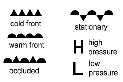
3. Weather map symbols.
|
|
|
This data is measured at many weather stations, either automatically or by meteorologists. The information is collected and used to produce weather maps for different regions. It is also used in computer models give us our weather forecasts.
|
Regional weather events: Fronts
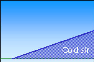
Frontal systems are formed when two air masses of different temperatures meet. Because warm air is lighter than cold air, the warm air rises above the cold layer. We name the fronts according to the fastest moving, approaching air mass. So if warm air is moving quickly towards cold air, the interface between the two air masses is known as a warm front. Weather changes are fast if a cold front passes, slower if it is a warm front.
|
Cold fronts occur when a fast moving cold air mass approaches a warmer air mass. Because the cold air is more dense than the warm air, it pushes the warm air up higher into the atmosphere and forms a cold layer beneath it. The warm air cools as it rises and, if it contains enough water vapour, this water condenses into clouds which may rain. Sometimes high clouds such as cumulonimbus form and, as a result, there are often thunderstorms and heavy rainfall. When warm fronts occur, the warm air climbs slowly into the atmosphere over the layer of cold air underneath. Because this process takes time, changes in weather are not so dramatic but take place over many hours or even days. Occluded fronts occur when a cold front overtakes a warm front.
|
|
 |
|
|
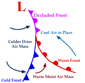
5. Low pressure system with a cold and a warm front. - Image from the University of Illinois WW2010 Project
ww2010.atmos.uiuc.edu/(Gh)/home.rxm
|
|
|
Movement of air in the atmosphere occurs because there are pressure differences between places on Earth. So how do these pressure differences come about?
General Circulation
Air pressure at the Earth's surface is different in different places and this is partially due to the different amounts of heat they receive from the sun. When the Sun heats up the Earth, the air above warms, becomes less dense, expands and rises. The air above is pushed upwards and then spreads out horizontally. Because of this horizontal air movement there is less air above the ground where the heating took place and this leads to an area of low pressure. As the air rises, it cools. As it cools, the air becomes more dense and sinks. This sinking means that there is more air above the ground in this area and a region of high pressure is formed. Air moves from high pressure areas to low pressure regions to even out the pressure differences, generating winds and atmospheric circulation as a result.
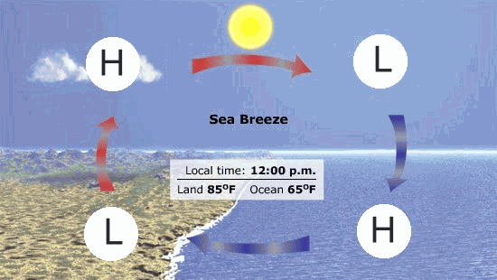
The same behaviour happens on a smaller scale during the formation of sea breezes during the day and land breezes during the night and these are shown in the animation below. During the day, the land heats up faster than the sea, warming the air above. During the night, the sea cools slower than the land so the air is warmer over the sea compared to the land. In both cases, the warm air rises and leaves an area of low pressure (L) below. Air from higher pressure (H) regions moves towards the low pressure regions to even out the pressure differences. At higher altitudes the air is transported back in the opposite direction.
|
 |
|
|
6. Sea breeze - land breeze animation (150 K).
Adapted from: Exploring Earth.
http://earthsci.terc.edu/navigation/home.cfm
|
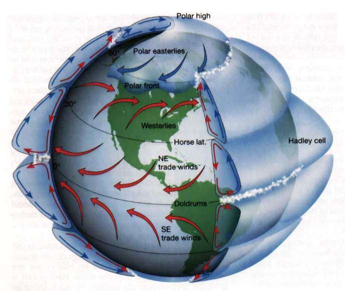
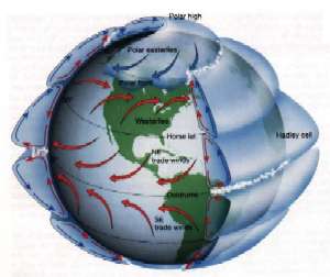
Around the Earth there are several major bands where high or low pressure dominate. At the equator, the warm ground heated by the energy of the Sun causes the air to rise leaving an area of low pressure. As the air rises, it cools and the water vapour it contains rains out. This is why the tropical regions are so wet. The air sinks back down to Earth at ~30oN and ~30oS resulting in bands of high pressure. Because the air has lost almost all of its water, the air that sinks is very dry and this is why you find the big deserts at these latitudes. At around 60oN and 60oS, cold dense air moving away from the poles meets the warmer air from nearer the equator. The warm air is less dense so is forced to rise, leading to areas of low pressure. This air cools and sinks forming a high pressure zone around the poles.
|
|
 |
|
|
7. The major global circulation cells and predominant wind directions around the Earth. The cells between the Equator and 30 oN and 30 oS are known as the Hadley Cells after the scientist who proposed them.
Source: University of Michigan.
Please click for higher resolution! (40 K)
|
|
|
As you move towards the poles, the rotation of the Earth (the Coriolis Force) leads to winds which are predominantly westerly in direction. Thermal and geographical factors (the presence of land, mountains and the oceans) also influence the weather at these latitudes. This makes determining the weather in these latitudes much more complicated than in the Tropics!
El Nino
As we can see, weather is governed by different systems which operate at different locations in a very dynamic atmosphere. Features such as the Hadley circulation cells operate all the time but there are also short term fluctuations in atmospheric circulation which lead to phenomena including El Nino and the North Atlantic Oscillation. Although short lived, these have huge impacts on our weather.
|
 |
|
|
8. Changes due to El Nino: Regions coloured in orange become dryer, those in blue become wetter and those shown in red become warmer. Source: NOAA.
|
|
|
El Niño results from a big water temperature anomaly in the Pacific Ocean near the Equator, west of South America. The phenomenon was first observed by Peruvian fishermen since it affects the amount and type of fish present in the water. Scientists have now shown that El Niño affects the weather in many continents. El Niño causes heavy rainfall in the southeast of South America but less rain in northern Brazil. It is also responsible for droughts in Australia and Indonesia and mild winters in North America.
|
|
Have a look at the topic on the WEATHER in the Climate Encyclopaedia to find out more about atmospheric pressure systems and local and global circulation patterns and their influence.
About this page:
author: Dr. Elmar Uherek - MPI for chemistry, Mainz
last published: 2004-06-11
|
|
|
|