|
|
 |
|
|
|
|
| |
|
|
|
Weather
Basics |
|
Why does air circulate? Which are the driving forces?
|
|
|
|
|
|
By the Sun heats different parts of the Earth differently, causes pressure differences. These pressure differences leave off due to the air circulate. This air force occurs on different scales, such as global scale (global earth circulation), medium scale (tornadoes) and local scale (mountain wind). Over some zones around the Earth, winds blow predominantly in one direction, over other areas, the prevailing direction changes with the seasons. Winds over most areas are variable from day to day. A wind is named according to the point of the compass from which it blows, e.g., a wind blowing from the north is a north wind.
|
|
 |
|
|
1. Windmill (c) FreeFoto.com
|
|
|
For most winds the Sun is the driving force, but there are other forces, which are also important:
|
|
1. Pressure Gradient Force (PGF) causes horizontal
pressure differences and winds.
|
 |
|
|
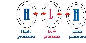
2. In absence of other forces, air moves from high to low pressure due to the "Pressure Gradient Force"
|
|
|
As we have learned above, winds begin with differences in air pressures. The greater the difference in pressures, the stronger the force. The distance between the area of high pressure and the area of low pressure also determines how fast the moving air is accelerated. Meteorologists refer to the force that starts the wind flowing as the "pressure gradient force".
|
|
2. Gravity causes vertical pressure differences. Gravity force is constant on a given high.
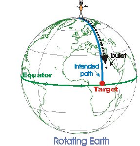
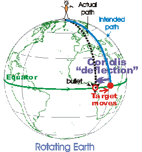
3. Coriolis Force Once the wind begins blowing the
Earth's rotation changes its direction. This is known
as the Coriolis effect.
|
It results in the deflection of all objects to the right in the direction of motion in the Northern hemisphere and to the left in the Southern hemisphere. The Coriolis force has important influence on large objects like air masses moving considerable distances. Small objects, for example ships at sea, are too small to experience significant deflections in direction due to the Coriolis Force.
4. Friction very little effect on air in the atmosphere,
but more important closer to the ground. The effect of
friction on air motion decrease as the altitude
increases to a point (usually 1-2 km) where it has no
effect at all. The depth of the atmosphere that friction
does play a role in atmospheric motion is referred to as
the boundary layer.
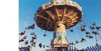
5. Centrifugal Force An object traveling in a circle
behaves as if it is experiencing an outward force. This
force, known as the centrifugal force, depends on the
mass of the object (the more massive the object, the
greater the force), the speed of rotation (the greater
the speed of the object, the greater the force), and the
distance from the center (the less distance from the
center, the smaller the force).
|
|
|
|
4. Everybody have experienced the centrifugal force while riding on a merry-go-round, being in a car that goes around a curve, or making a sharp turn on a bike.
Photo by Patricia Marroquin © http://www.betterphoto.com/gallery/
dynoGallByMember.asp?mem=2083 |
|
Land and Sea Breezes
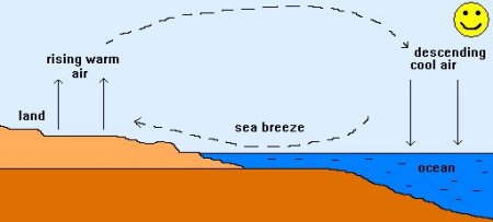
Water has a much greater heat capacity than land, i.e. water heats up much slower than land, and, can keep the warmth much longer. During the day, near large bodies of water, the land and the water develop a temperature difference, mainly because of this different heat capacities. As weve learned, by the Sun heats different parts of the Earth differently, causes pressure differences. In the same way, on a warm summer day along the coast, this differential heating of land and sea leads to the development of local winds called sea breezes.
|
 |
|
|
5. Source: http://www.ace.mmu.ac.uk/eae/ ©
|
|
|
A sea breeze develops when the land become much warmer than the sea on a sunny day. As the land warms up, the air above it expands and begin to rise, being lighter than the surrounding air. To replace the rising air, cooler air is drawn in from above the surface of the sea. |
 |
|
|
6. Source: http://www.ace.mmu.ac.uk/eae/
|
|
|
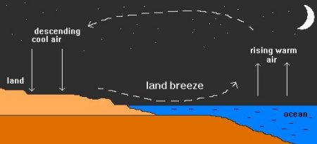
At night the water does not cool as much as the land, so the circulation reverses and the surface air moves from the land to the water; this is called a land breeze.
|
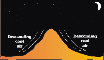
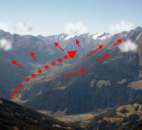
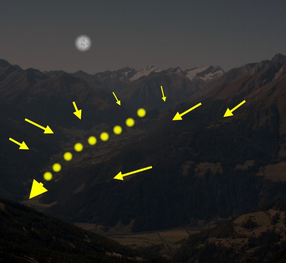
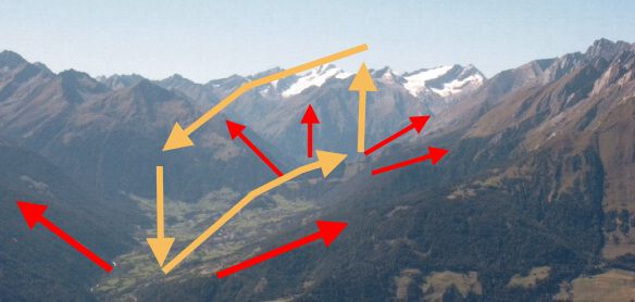
Mountain and Valley Breezes
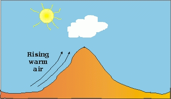
In mountainous regions we find special wind systems. The slopes of the mountains and the narrow parts of the valley are more intensively heated by the sun, than the wider ground of the valley or the forelands. This leads to valley breezes during the day and mountain breezes during the night. What does this mean?
|
 |
|
|
8. Simple slopewind circulation © Dept. for phys. geography, Univ. of Kiel
|
|
|
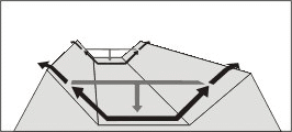
We can imagine, that if slope winds go up the hill during the day or down the hill during the night, this moving air has to be replaced. We could think: on the hillsides the air goes up, in the middle of the valley it falls down again. We have a slopewind circulation as shown on the left. But this is only observed during a short time of the day. Because a typical valley is a bit more complicated ...
|
|
The more narrow a valley is the higher the percentage of the slopes, and the more air is rising. This rising air is replaced from the parts of a valley or even the plain in the forelands of the mountains, where we find less slopes. So the wind during the days comes usually from the lower and flatter parts of a valley system and goes up. Since the name of the wind is always given by the place or direction where it comes from, we call this wind valley breeze. During the night the cool air falls down along the slopes into the valley. The breeze goes in the opposite direction. It comes down from the mountains and goes to the plains and the wide ground of the valley. Therefore it is called mountain breeze.
|
 |
|
|
10. Local circulation during the valley breeze
Certainly, like for the land and sea breeze, also here air which moves on the ground and rises somewhere has to move back and come down again. This takes place in higher altitudes. So, we have a local circulation again. The scheme shown above may be a bit too simple, because mountains are structured and have many side valleys. But it shows the basic system.
|
Compiled by Vera Schlanger & Szabolcs Bella - Hungarian Meteorological Service
Scientific reviewing: Dr. Ildikó Dobi Wantuch / Dr. Elena Kalmár - Hungarian Meteorological Service, Budapest
Last updated 2003-10-17 |
Further reading:
http://www.infoplease.com
http://www.ux1.eiu.edu
http://phun.physics.virginia.edu
http://cimss.ssec.wisc.edu
http://www.research.umbc.edu
http://www.doc.mmu.ac.uk/aric/ |
|
|
|