|
|
 |
The simulation of the Gulf Stream
Film courtesy: Deutsches Klimarechenzentrum, Hamburg 1992, and 2002 for the digital version (http://www.dkrz.de)
Attention:
If you cannot see anything, please install the Microsoft Media Player (TM) or the RealPlayer (TM) first.
If you have a slow modem it is better to save the file on your hard disk and run it later. If you have a fast connection, then just run the movie.
Exercise:
Load these films and read the commentary.
Depending on your movie player you may wish to enlarge the screen and place it to the left of the commentary.
|
|
|
|
In this animation you can see how warm water masses move from the Gulf of Mexico towards Europe.
Watch the red and yellow arrows which indicate warm water. Notice that the water temperatures off Canada are lower than those off Northern Europe.
The Gulf Stream and the North Atlantic Current are the reasons why Western and Northern Europe are warmer than other regions around the world which are at the same latitude. |
|
|
|
You can now see the empty depth of the Atlantic.
The simulation shows single water currents on the surface travelling towards the North East.
Notice how they sink into the deep ocean in the polar region and become colder and colder.
Decades later, the cold water travels south in the deep Atlantic Ocean. |
|
|
|
|
|
|
|
Notice the extremely deep hollows in the Atlantic off Greenland and Norway.
Follow the single currents and see how they dive into these two deep areas.
These are the areas where the surface waters cool, become more dense and sink to the bottom of the ocean to form new deep water. This formation of new deep water is of the major controls on the ocean's thermohaline circulation.
The surface plot shows how we think these areas will decrease in size as a result of global warming. This will reduce the amount of new deep water formed and slow down or even stop the thermohaline circulation. This has huge implications for our climate. Have a look in the Oceans and Climate Topic in the Read More Section for details. |
|
The open question is: How will this influence the climate?
|
|
|
|
Find out the facts. Use your atlas. |
|
| 1) Surface waters move from Mexico bringing ... |
|
|
| 3) Water sinks to the deep ocean in the North Atlantic because it .. |
|
|
| 5) The maximum sea depth off the coast of the West coast of Greenland is approximately... |
|
|
| 7) The maximum sea depth off the coast of Norway is approximately... |
|
|

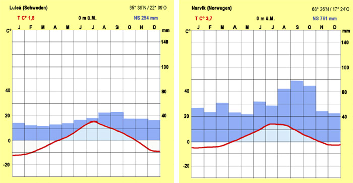
9) Where is this climate diagram from?
(left axis shows precipitation in mm, right axis shows temperature in ºC, x axis is in months)
Help needed? Click here! |
|
|
|
|
| 2) The water temperatures off Norway are ... |
|
|
| 4) The thermohaline circulation in the North Atlantic means that ... |
|
|
| 6) The sea south of Greenland is called ... |
|
|
|
8) The sea south of Norway is called the ... |
|
|
| 10) And why is this surprising? Because the town is at a latitude of ... |
|
| | |
|
|
|
Attention: This quiz is optimised for Internet Explorer and new versions of Netscape!
If the little answer window disappears, just reopen it using the 'Show solution' button! |
|
|
|
|
|
|
|
|
Exercise:
And for further discussion, compare the 2 diagrams and explain how the Gulf Stream exerts its influence.
|
 |
|
|
climate diagrams of Lulea and Narvik, author: Julia Heres
|
About this page:
- Author: - Prof. Dr. Schrettenbrunner - University of Nürnberg - Germany
- scientific reviewing:
- educational reviewing: Dr. Schleicher / J. Heres
- last update: 06.11.03
|
|
|
|