|
|
 |
|
|
|
|
| |
|
|
|
Weather
Basics |
Fronts
A weather front is defined as the inclined boundary between two air masses of different temperatures and densities. They cannot mix together immediately owing to their different densities. Instead of the lighter, warmer air mass begins to rise above the cooler, denser one, and, the front is the transition between them.
|
|
|
|
|
|
|
Weather fronts often travel from west to east, because westerly winds are typical for the mid-latitudes where front systems occur. Fronts can however also be affected by geographic features like mountains and large bodies of water, especially at the lower levels of the atmosphere.
|
Fronts are always accompanied by clouds of all types, and very often by precipitation. But, when weather front passes over an area, it is marked also by changes in wind speed and direction, atmospheric pressure, and moisture content of the air. There are four types of fronts: cold front, warm front, occluded front and stationary front. The type of front depends on both the direction in which the air mass moving and the characteristics of the air mass.
|
|
 |
|
|
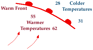
1. Front over the Findon coast
source: http://www.abdn.ac.uk/physics/meteo/metoh12_files/frame.htm
|
|
|
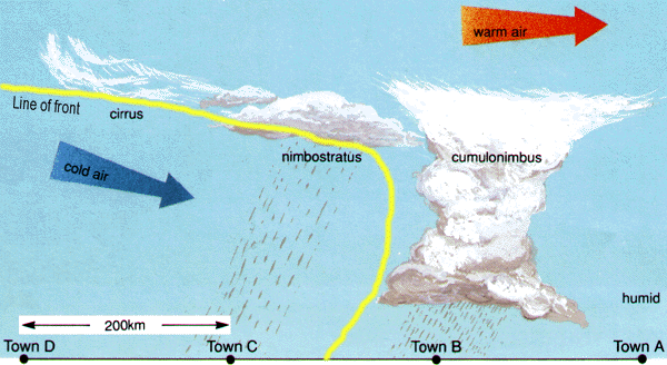
Cold fronts
Cold fronts occur when a colder air mass replacing a warmer air mass. At cold front the cold air follows the warm air, and, because cold air is denser, pushes warm air out of its way, forcing the warm air to rise.
|
 |
|
|
2. cold front
source: http://www.ckkc.co.uk/html/stories/metrolgy.html
please click to enlarge! (100 K)
|
|
|
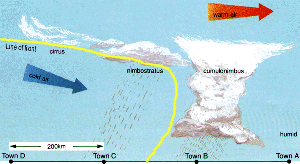
The lifting warm air mass becomes cooler, and clouds start to form. Precipitation at cold fronts are usually heavier although less extensive (50-70 km) and less prolonged. The reason for this is that the uplift of warm air is stronger due to the undercutting of cold air. Such a way towering clouds form, and rain, thunderstorms, hail and tornadoes can occur.
The air behind a cold front is noticeably colder and drier than the air ahead of it. When the cold front passes through, temperatures can drop more than 15 degrees within the first hour.
|
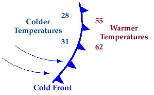
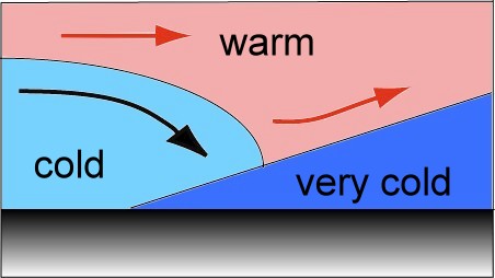
3. Image right:
Symbolically, a cold front is represented by a solid blue line with triangles along the front pointing the warmer air and in the direction of movement. (The temperature is in the Fahrenheit units on the figure.)
Source: University of Illinois http://ww2010.atmos.uiuc.edu/(Gh)/home.rxml
|
|
|
|
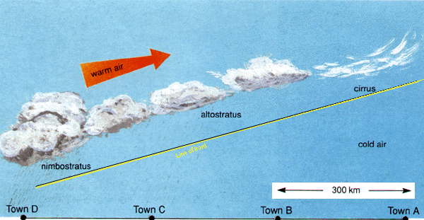
Warm fronts
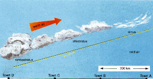
Warm fronts occur, when a warmer air mass approaches a colder air mass. The warmer air lifts up and over the colder air. Warm fronts are usually more gentle than cold fronts, move slowly, gently settling over the cold front and moving it out of the way. Precipitation at warm fronts are usually less heavy although more extensive (300-400 km), than at the cold fronts.
|
 |
|
|
4. warm front
source: http://www.ckkc.co.uk/html/stories/metrolgy.html
please click to enlarge! (100 K)
|
|
|
The air behind a warm front is warmer and more moist than the air ahead of it. Warm fronts bring more steady, lighter rain or snow in front of them, which can last from a few hours to several days. When a warm front passes through, the air becomes noticeably warmer and more humid than it was before.
|
The first signs of the warm front are the cirrus clouds, followed by the cirrostratus, altostratus, nimbostratus and stratocumulus types of clouds. The distance of the cirrus clouds can be up to 1000 km from the front line on the surface. All these type of clouds have mostly horizontal structure, because of the low slope of the front surface, inspite of the cold fronts, where the clouds have mostly vertical structure.
|
|
 |
|
|
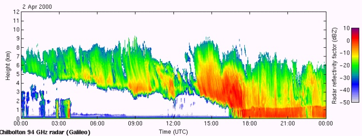
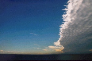
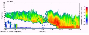
5. Radar image of warm front clouds
source: http://www.abdn.ac.uk/physics/meteo/metoh12_files/frame.htm
|
|
|
|
|
6. Picture on the left:
Symbolically, a warm front is represented by a solid red line with semicircles pointing towards the colder air and in the direction of movement.(The temperature is in the Fahrenheit units on the figure.)
Source: University of Illinois http://ww2010.atmos.uiuc.edu/(Gh)/home.rxml
|
|
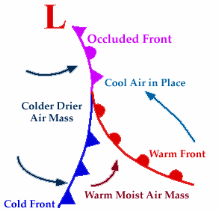
Occluded front
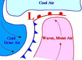
Occluded fronts occur when cold, warm and cool air come together. The occluded front has two main types: Cold and warm occluded fronts. In both cases a cold front overtakes a warm front.
In the case of cold occluded front, a very cold front overtakes a warm front. The cold front lifts both the warm air gliding above the cooler air and also the cool air on the ground and creeps underneath. So the warm front becomes an upper level front. The general behavoir of the weather is similar to the warm front at the beginning, but it is like a cold front at the end, with heavy precipitation. The cloudiness is mixed, not well characterized as for the other front types.
|
 |
|
|
8. Formation of a cold occluded front
Source: University of Illinois http://ww2010.atmos.uiuc.edu/(Gh)/home.rxml
|
|
|
|
|
A warm occluded front means, that a cold front of moderate cool air overtakes a warm front. But in the warm front the temperature difference is high, because the air on the ground is very cold. So the whole cold front with cooler air glides together with the warm air on the very cold air mass. The cold front becomes the a upper level front. In this case the weather is similar to a warm front.
A stationary front is given, when a warm/cold front boundary with neither cold nor warm air advancing. They behave like warm fronts, but are more quiescent.
|
About this page:
author: Vera Schlanger - Hungarian Meteorological Service
scientific reviewing: Dr. Ildikó Dobi Wantuch / Dr. Elena Kalmár - Hungarian Meteorological Service, Budapest
last updated: 2003-10-17
|
Further reading:
http://www.ckkc.co.uk/html/stories/metrolgy.html
http://www.cira.colostate.edu/RAMM/picoday/discussion.html
http://www.abdn.ac.uk/physics/meteo/
http://ww2010.atmos.uiuc.edu/(Gh)/indexlist.rxml
|
|
|
|