|
|
 |
|
|
|
|
| |
|
|
|
Higher Atmosphere
Basics |
The layers of the atmosphere
The different layers of the atmosphere are determined by different physical properties. The temperature changes with the altitude, the pressure decreases and with the pressure also the density of the air. The higher we go, the less molecules we find in the same volume (e.g. 1 m3). Also the humidity and the wind speed change ...
|
|
|
|
|
|
 |
|
|
1. blue sky above the clouds
source: freefoto.com
|
|
|
All this is not visible from the ground if we look to the sky. We either see clouds or a clear blue sky without any sort of layer. The blue comes from the blue part of the white sunlight. This is because the molecules in the air have different influences on different colours (= different wavelenghts) of the visible light. But what about layers? Can we observe them at all?
We get an idea that the properties of the atmosphere change with altitude if we go by plane. Independent from the local weather below the clouds we see a blue sky and no clouds above us if we reach an altitude of about 10-11 km. In this case we are in the tropopause or even in the lower stratosphere. There are no clouds anymore, because there is not enough water.
|
Why does the temperature change?
There are small scale temperature changes in the atmosphere which have local reasons. E.g. the land cools and heats more quickly than the sea. Or cold winds from the mountains can change the temperature in the boundary layer. But more general for the global average there are two reasons for the main temperature changes:
a) The Earth surface absorbs sunlight and heats up. The higher you go from the warm Earth surface towards the cold space, the cooler the air becomes. Temperature decreases with altitude.
|
|
 |
|
|
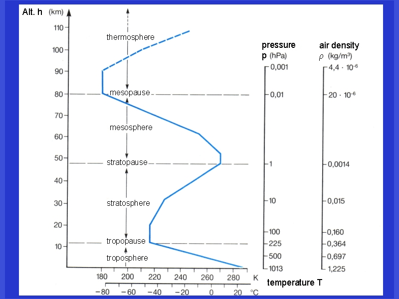
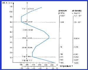
2. The temperature profile, presssure and densitity of the air with increasing altitude
adapted from: Schirmer - Wetter und Klima - Wie funktioniert das?
Please click to enlarge! (120 K)
|
|
|
b) This general rule can be annuled or superimposed , if molecules in the air absorb parts of the solar radiation and heat up the air themselves. In this case the temperature increases until we reach a local temperature maximum. This is the case in the ozone layer in the stratosphere, where ozone absorbs UV-light and the temperature maximum (stratopause) defines the border between stratosphere and mesosphere. In the mesosphere temperature decreases again. Another temperature increase takes place in the thermosphere, where nitrogen and oxygen absorb the extremely energetic short UV-light of the sun and are partially ionised. Therefore this layer is also called ionosphere.
|
 |
|
|
3. Like a pillow tower:
How air is compressed ...
by Elmar Uherek
|
|
|
Why does the pressure decrease?
The difference between air and water is, that air is compressible and water is not. If you are diving in the sea and you have 10m of water above you, the pressure is 1 bar, if you have 20m of water above you it's 2 bar, because the amount of water doubled. Air is a little bit as if you would try to pile up very light pillows. The pillows on the bottom of the tower would become rather flat due to the weight of the ones above. They can be compressed because there is a lot of free space in them. Finally in the first layer on the ground you have 10 pillows in 30 cm and in the 8th layer only one, although all of them have the same weight. That's the same in the atmosphere. Therefore climatologist very often do not only use the unit meter in order to specify the altitude but also use the pressure. The compressibility depends a little bit on the temperature, but roughly we can divide the pressure by a factor of 2 every 5.5 km of altitude. 1000 hPa at the ground, 500 hPa in 5.5 km altitude and so on.
Please click here for more detailed information on the pressure calculation (formula).
Is the thermosphere really that hot?
Profiles of the atmosphere show sometimes temperatures of 500-1000°C in 200-500 km altitude in the thermosphere. Is it really that hot? The problem in this case is the definition of temperature. The molecules in the air have a certain energy. If we measure it with a thermometer the molecules transfer their energy while hitting the thermometer surface. In the altitude of the thermosphere the molecules have a very high energy so that the temperatures are correct, but the number of molecules per volume is about one millionth of the number near the Earth surface. So the probability of collisions (e.g. with a thermometer) and the total energy transfer is extremely low. Therefore, thermospheric temperature is a measure of molecular energies. But you cannot really compare it to temperatures measured with a thermometer at the ground.
|
 |
|
|
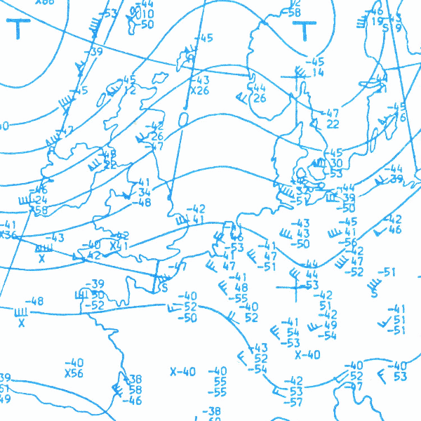
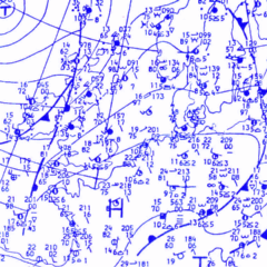
4. a) weather map at ground level
from: Schirmer - Wetter und Klima - Wie funktioniert das?
|
|
|
 |
|
|
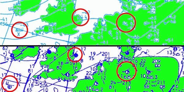
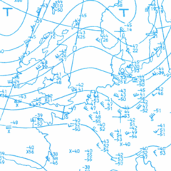
4. b) the same weather map at 300 hPa (about 9 km altitude). Please note the wind speed symbols!
from: Schirmer - Wetter und Klima - Wie funktioniert das?
|
|
4. c) Have a look on the cutout on the right and compare the wind speeds at the ground (deep blue below) and in 9 km altitude (light blue above) at comparable places. What is the wind speed in km/h at the three marked locations?
Click the image for full size!
(90 K)
|
|
|
 |
|
|
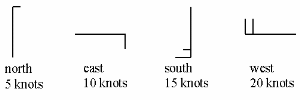
5. Wind speed is traditionally measured in knots (kn = seamile/h) or in km/h, more correctly in m/s.
1 m/s = 3.6 km/h
1 kn = 1.852 km/h
The symbols in the weather map tell us the wind direction (Where does the wind come from?) and the wind speed in knots.
|
|
|
How does the wind change?
The two weather maps above (300 hPa = about 9 km and 1000 hPa) show, that pressure gradients and wind speeds differ a lot near the ground and in the upper troposphere. Therefore, for air traffic, a special weather forecast system is necessary. Wind speed increases with the altitude and normal wind speeds near the tropopause would be severe storms at the ground. In the stratosphere however, not only the temperature trend changes, also the wind speed decreases significantly.
|
|
|
|
 |
|
|
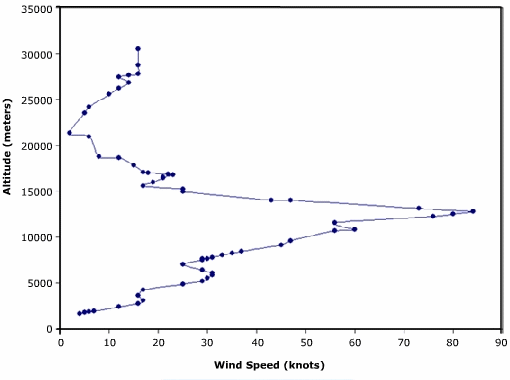
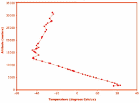
7. Comparison of wind speed and temparature.
Please click to enlarge! (60 K)
|
|
About this page:
author: Dr. Elmar Uherek - Max Planck Institute, Mainz
scientific reviewer: Dr. John Crowley, Max Planck Institute for Chemistry, Mainz - 2004-05-04
educational proofreading: Michael Seesing - Univ. of Duisburg, Dr. Ellen K. Henriksen - Univ. of Oslo, Yvonne Schleicher - Univ. of Erlangen-Nürnberg
last published: 2004-05-05
|
|
|
|